
If you take public transportation, this is a question you’ll ask yourself often. Especially if you’re at a certain distance from your destination (or transfer) where you could choose to walk. Maybe it’s raining or you’re running late, but to make the right call, you’ll need to know approximately how long you’d be waiting for that next bus. By using a Bus app, you don’t have to wonder.
This is also helpful when there are a choice of busses running along similar routes, some local” making lots of stops and another “express”, making fewer stops but with less frequency.
Using Bus Times App
Here we’ll give a quick tour of the functionality of our London bus app. Features in the app for your local area may vary but the principles will likely be similar, so it’s worth a quick eyeball.
Open the app ![]() on your smartphone (after all, this app is most helpful when you’re on the go and need live information enroute). You’ll see a screen similar to the below. Until you’ve been using the app awhile, choose bus stops nearest you. (The other are for frequent or recent choices, which won’t apply on your first use.) See yellow circled area.
on your smartphone (after all, this app is most helpful when you’re on the go and need live information enroute). You’ll see a screen similar to the below. Until you’ve been using the app awhile, choose bus stops nearest you. (The other are for frequent or recent choices, which won’t apply on your first use.) See yellow circled area.

In the case of London, the single letters (eg G or B) refer to the bus stop. The sign at the physical bus stop will match that letter. Note there is a different letter for the same bus route in the opposite direction as those buses will stop on the other side of the road. The numbers or combination of a letter and numbers on the app refers to the number of the buses that serve that stop and should be the same in either direction.
Now select the bus number or route you desire. (See below, circled.) It will say a key destination it’s travelling toward, so make sure you tick the one traveling in your desired direction. In large font it will say how many minutes until the next bus arrives. In small font below it will say the next 2 times after that (in case you’re not close enough to reach the stop in time for the first). In the case below, the next bus is in 2 minutes, the 2nd bus in 14 minutes and the third one will arrive 20 minutes from now.

Accessing Details of the Route
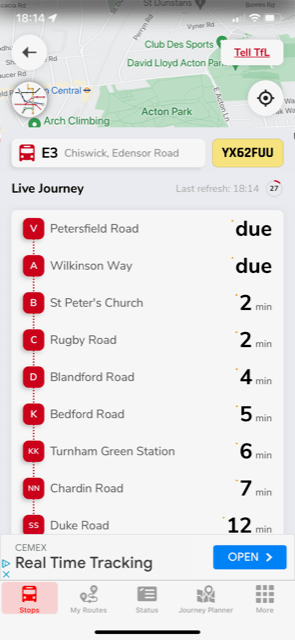
If you tap on your bus route, it will open a screen that shows you the route of the bus, starting from one or two stops before yours and showing a screens’ worth of stops that follow. So in the case below, our nearest stop is St Peters Church, to which it’s expected in 2 minutes. You can see that it is “due” already at both of the stops ahead of ours. So in fact, it might be a minute or so late, depending on how far those stops are and traffic. It’s helpful to know in case you’re undecided if it’s worth hustling to get to your stop in 2 minutes. In this case, I’d bet you’d still be fine getting there in 3 minutes. In addition, this feature tells you in how many minutes from now you can expect the bus to arrive at each of the stops beyond yours. In the example below, if we catch this next bus in 2 minutes, it will be expected to arrive at Duke Road in 12 minutes. This is handy if you are trying to coordinate with a friend, either at your point of arrival or part way along your route.
How to Use the Journey Planner
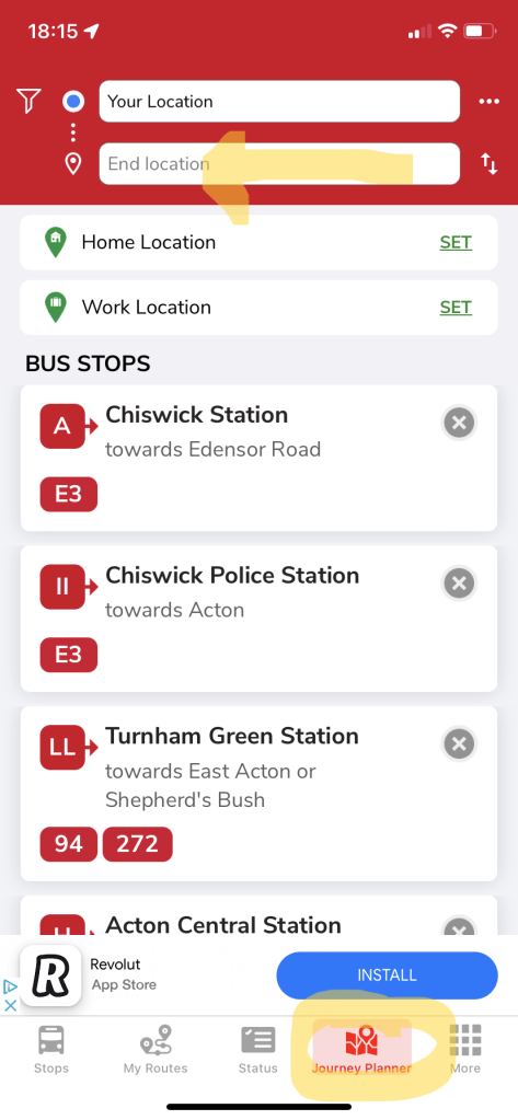
The bus times app also serves as a journey planner if you want to know your options how to get from point A to point B. It covers bus journeys as well as travel by tube, in the case of London. It will also tell you the total fare at the time of your search. You will find the Journey Planner function in the bottom menu (circled in yellow below). If your journey begins from where you are currently, your smartphone will automatically take that into account. So simply choose a destination by ticking the “End Location” field shown below with a yellow arrow and start typing. Press enter and the search will bring up matches which you can then confirm.
If you’ll be travelling from a different location (for example you’re trying to see how you’ll get from a restaurant you’ll be dining at later to a club), tap on the “Your Location” and start filling that in with your start point.
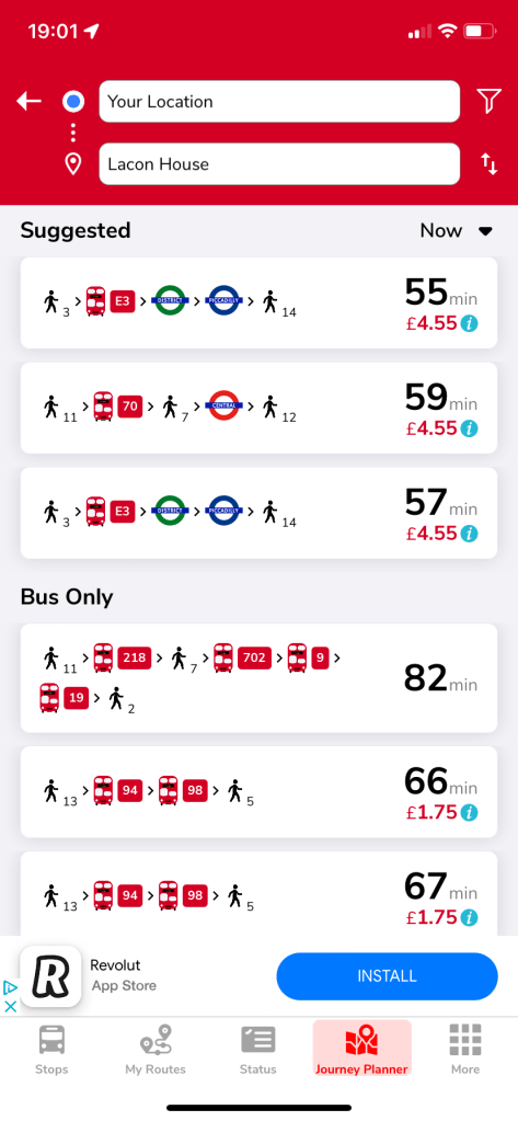
Options will then come on screen with your travel options by route, time and cost. The number below and to the right of each walking figure indicates the average walk time at that leg of the journey. So in the first option below, there will be a 3-min walk to the bus stop then a 14 minute walk after the second train leg in order to arrive at the destination. If you tap the little ‘i‘ next to the cost of the journey, it will bring up details as to any cost fluctuations by time of day.
What Else?
By tapping “More” (see below, circled in yellow), you’ve got loads of special features at your fingertips including setting updates, checking for road or bus route disruptions, etc.

Now there’s no excuse for being at the mercy of a bus that never arrives. You can grab back more control by knowing how long it should actually take and alternative options if the wait times for your original plan doesn’t suit.
Let us know what you thought of this post by voting below. And if you’re not already subscribed, you’re missing out. Simply fill in your email and hit “Subscribe” to receive a free weekly email.
